 |
 |
 |
 |
|
 |
 |
 |
 |
 |
 |
 |
 |
 |
 Frome Valley Walkway and other walks
Frome Valley Walkway
(OS Explorer Map Nos:-155 Bristol & Bath & 167 Thornbury, Dursley & Yate)
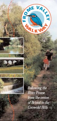
The Frome Valley Walkway is a pleasant and interesting 18 mile long path which follows the River Frome between the River Avon in Bristol and the Cotswold Hills in South Gloucestershire.
The path passes through a variety of landscapes including open countryside and meadows in South Gloucestershire, the mediaeval town of Chipping Sodbury, wooded valleys south of Winterbourne Down, the pretty village of Frenchay and historic, landscaped parks in Bristol.
A free, illustrated, full-colour booklet describing the Frome Valley Walkway is available. You can view and download a full copy of the booklet here:
frome_valley_booklet.pdf (1.77Mb)
To receive the most recent update of the Frome Valley Walkway Booklet which includes 5 additional short circular walks to interesting places in the Valley, please contact:
the Avon Frome Partnership 0117 922 4325 or
South Gloucestershire Council 01454 863725
Other linked routes to view or download
Jubilee Way
Severn Way
The Dramway
River Avon Trail
Monarch's Way
Cotswold Way National Trail
Bristol & Bath Railway Path
|
|